The Gurung Villages Trek operates as a distinct alternative to the high-altitude expeditions typical of the Annapurna region. It traverses the mid-hills of the Gandaki Zone. The route focuses on the cultural geography of the Gurung people rather than solely on alpine topography. The trek loops through established settlements such as Ghandruk, Landruk, Majgaun, and Dhampus. These villages occupy the ridges and shelves flanking the Modi Khola river. The experience prioritizes ethnographic immersion and architectural observation over vertical accumulation. It functions as an efficient mechanism for accessing Himalayan views and indigenous culture within a compressed timeframe.
Demographic and Historical Context
The Gurung people, or Tamu, trace their lineage to Tibeto-Burman roots. Historical linguistic analysis suggests a migration from Tibet across the Himalayas to the central hills of Nepal around the 6th century. They established dominance in the districts of Kaski, Lamjung, Gorkha, Syangja, and Manang. The topography defined their economy. They developed a dual reliance on high-altitude animal husbandry and terrace agriculture. Sheep farming utilizes the alpine pastures in summer, while crop cultivation occupies the lower slopes.
A defining element of Gurung history is the martial tradition. The Gorkha Kingdom recruited Gurung men into its army during the unification of Nepal in the 18th century. Subsequently, the British East India Company and later the British Army integrated them into the Brigade of Gurkhas.
This service history impacts the village economy. Remittances fund infrastructure. Slate roofs and stone-paved courtyards reflect this capital influx. Many older men in the villages speak fluent English and possess knowledge of global geography derived from service in Hong Kong, Singapore, or the UK. This creates a specific social dynamic where traditional agrarian practices coexist with a globalized outlook.
The social structure centers on the “Rodhi Ghar,” a communal dormitory system that traditionally facilitated socialization among the youth. While modernization has eroded the strict function of the Rodhi, the communal ethos remains. The “Ama Samuha” (Mothers’ Group) manages village hygiene and cultural programs. These structures govern the hospitality industry within the villages.
Topography and Balcony Viewpoints
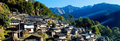
The route stays primarily between 1,000 meters and 2,000 meters. This elevation band avoids the sterile rock and ice of the high sanctuary. Instead, it traverses the “balcony” zone. The villages sit on geological shelves that protrude from the steep valley walls. This specific positioning creates a grandstand effect. The Annapurna massif rises directly behind these settlements.
Ghandruk serves as the primary example of this topography. The village faces east. It receives the morning sun. The view encompasses Annapurna South (7,219m), Hiunchuli (6,441m), and Machapuchare (6,993m). The angle of observation differs from the base camp. Here, the mountains form a backdrop to the agricultural foreground. The contrast between the golden terraces of wheat or barley and the white ice of the peaks defines the visual aesthetic.
Landruk sits on the opposing side of the Modi Khola valley. The trek between the two involves a descent to the river and an ascent of the opposite bank. From Landruk, the view looks back at the cliffs of Ghandruk and up toward the sanctuary entrance. Majgaun and Dhampus occupy ridges further south. Dhampus offers a panoramic sweep of the entire range, extending west to Dhaulagiri and east to the Manaslu range. These viewpoints require minimal vertical effort compared to the high ridges of Poon Hill or Khopra. The village squares themselves function as the observation decks.
Architecture and The Homestay Ecosystem
Accommodation on this trek shifts between standard lodges and community-managed homestays. The homestay model in the Gurung villages differs from a standard bed and breakfast. It operates under a rotation system managed by the village tourism management committee. This distributes revenue across households.
The physical structure of the accommodation reflects local geology. Traditional Gurung houses utilize dry-stone masonry. Craftsmen stack local slate and rock without mortar. They plaster the walls with red clay and cow dung for insulation. The roofs consist of overlapping slate tiles. Woodwork on windows and doors features intricate geometric carvings.
Staying in a homestay places the trekker within the domestic sphere. The kitchen serves as the social nucleus. An open hearth or a clay stove dominates the room. Meals are consumed here. The menu relies on local production. “Dal Bhat” remains the staple, often supplemented with “gundruk” (fermented leafy greens) and locally butchered meat. Millet functions as a primary crop. It ferments into “Raksi” (distilled spirit) or “Tongba” (hot beer). Consumption of these beverages is often part of the evening protocol.
The bedroom facilities in homestays are spartan. The focus is on the interaction rather than hotel-grade amenities. Guests sleep in rooms vacated by family members or in purpose-built annexes. The proximity to the host family removes the barrier present in commercial lodges. It allows for direct observation of daily rituals, from the morning puja to the evening processing of crops.
Daily Exertion and Route Characteristics
The trek is classified as a “short trek.” This designation refers to the duration, typically three to five days, rather than a lack of physical demand. The terrain involves significant undulation. The “Nepali Flat” concept applies here: a trail that constantly rises and falls while maintaining a general elevation.
The stone staircases present the primary physiological challenge. The path to Ghandruk or the ascent from the river to Landruk consists of thousands of flagstone steps. This activates the quadriceps and calves. However, the daily walking hours remain manageable, averaging four to five hours. This pace allows for extended stops in the villages. The objective is not just to reach the destination but to engage with the environment.
The altitude profile stays well below the threshold for acute mountain sickness (AMS). Acclimatization days are unnecessary. This factor makes the trek viable for demographics excluded from higher routes, such as older trekkers or those with minor respiratory conditions. It fits tight schedules. A trekker arriving in Pokhara can start the trek the next morning and complete a substantial loop within 72 hours.
Flora and Agricultural Cycles
The trail moves through distinct ecological bands. The lower sections traverse terraced fields. In February, these fields often hold winter crops like wheat, barley, or potatoes. The agricultural cycle dictates the visual texture of the landscape. The terraces modify the steep slopes into manageable strips of arable land. The irrigation systems rely on gravity-fed channels that divert water from the streams.
Above the cultivation line, the trail enters the subtropical broadleaf forest. The rhododendron arboreum dominates the canopy. February marks the beginning of the blooming season. The lower elevation rhododendrons flower earlier than their alpine counterparts. Red and pink blooms punctuate the green canopy. This forest supports a diverse avian population. Birdwatchers utilize this route to spot laughing thrushes, magpies, and raptors riding the thermals.
The forest sections also contain Himalayan nettle (Allo). The villagers harvest this plant to produce fiber. Weaving constitutes a secondary economic activity. Trekkers often see the processing of these fibers in the village courtyards.
February Logistics and Promo Details
Glacier Safari Treks targets the late winter window for this itinerary. The specific departure dates are February 10, February 23, and February 27. February occupies a transitional meteorological niche. It sits between the cold of deep winter and the haze of the pre-monsoon spring.
The weather in February offers distinct advantages. The air retains the crispness of winter. Humidity remains low. This results in exceptional visibility. The mountains appear sharp against the blue sky. The haze that accumulates in late March and April due to rising temperatures and forest fires is absent. Daytime temperatures in the sun are pleasant, ranging from 10°C to 15°C. Evenings require thermal layers as temperatures drop to near freezing.
The trail traffic in February is lower than the peak season of October or April. The tea houses and homestays have excess capacity. This ensures better service and a quieter trail experience. The promotional push for these dates leverages this window of optimal visibility and low crowd density.
Cultural Specifics: Dress and Religion
The Gurung culture manifests visually in traditional attire. Men wear the “Bhangra,” a white cloth crossed over the chest like a knapsack, used for carrying provisions. The “Kachhad” is a wrap-around lower garment. Women wear velvet blouses and lungis, often adorned with gold jewelry and semi-precious stones. The “Tikis” (glass bead necklaces) denote marital status.
Religion in the Gurung villages represents a syncretism of Buddhism, Hinduism, and the indigenous Bon shamanism. Buddhist monasteries (Gompas) occupy prominent positions in the villages. Prayer flags flutter from rooftops. However, the “Pachyu” (shaman) and “Ghyabre” (priest) still perform rituals for protection, healing, and ancestor worship. These rituals often involve animal sacrifice and specific chants. The coexistence of these belief systems is visible to the observer. A trekker might pass a Buddhist mani wall and a Hindu shrine within the same hour.
Economic Impact of Tourism
Trekking functions as a primary revenue stream for these villages. The ACAP (Annapurna Conservation Area Project) model retains entry fees for local development. This contrasts with centralized national park models. The funds support trail maintenance, sanitation projects, and school funding.
Spending money in the villages has a high multiplier effect. Purchasing water, snacks, or handicrafts puts cash directly into the local household. The homestay model maximizes this retention. The leakage to external operators is lower compared to camping treks where supplies are imported. The “Limited Feb departures available” signal implies a capacity management strategy that aligns with this community-based approach. Overloading the villages dilutes the experience and strains the infrastructure.
Access and Connectivity
The trek begins and ends near Pokhara. The drive to the trailhead at Nayapul or Phedi takes less than two hours. Recent road construction has extended jeep tracks further into the hills. This development is contentious. It improves access for locals but shortens the trekking route. The itinerary selects trails that avoid the dust of the new roads.
Connectivity in the villages is surprisingly robust. Mobile networks (Ncell and Nepal Telecom) cover most of the ridges. Data access allows trekkers to share the “balcony views” in real-time. WiFi is available in most lodges. This digital layer overlays the traditional setting. It allows for safety communications and instant logistics management.
The Role of Guides
Glacier Safari Treks employs guides often drawn from the Gurung community. This staffing choice transforms the guide from a route-finder into a cultural interpreter. A guide from the region explains the significance of the “Rodhi,” identifies the specific clan markers in the architecture, and facilitates the interaction with host families. They navigate the language barrier. While many villagers speak English, the deeper nuances of the culture require translation. The guide manages the pacing on the stone steps and ensures the arrival at the viewpoints coincides with the optimal light.
Gear and Preparation
The gear requirement for the Gurung Villages Trek is lighter than for high-altitude treks. A heavy down suit is unnecessary. Layering remains key. A fleece and a windproof shell handle the daytime conditions. A medium-weight down jacket suffices for the evenings. The footwear choice should prioritize stability on stone. Stiff-soled hiking boots protect the feet from the impact of the steps. Trekking poles are highly recommended. They reduce the eccentric load on the knees during the long descents.
A sleeping bag is still advisable, even in homestays. It ensures hygiene and thermal consistency. The Feb dates require a bag rated to at least -5°C.
Conclusion
The Gurung Villages Trek offers a concentrated dose of the Himalayan experience. It removes the physiological barrier of extreme altitude. It replaces the sterile alpine environment with a living, working cultural landscape. The views of Annapurna South and Machapuchare from the Ghandruk or Dhampus ridges compete with those from higher elevations. The architecture, history, and hospitality of the Gurung people provide the narrative context.
For the February departures on the 10th, 23rd, and 27th, the conditions favor the photographer and the cultural enthusiast. The visibility is high. The crowds are low. The rhododendrons begin their display. It is a strategic choice for the trekker seeking maximum signal density of visuals and culture within a short duration. Booking the February slots requires immediate coordination with Glacier Safari Treks. The capacity in the homestays and the guide allocation dictate the limits.