Table of Contents
Every June, a predictable drama unfolds across Nepal. The clouds roll in from the Bay of Bengal, the trails turn to soup, and trekkers glumly reschedule their Annapurna Circuit plans for October. Meanwhile, a small and suspiciously cheerful group of travellers quietly boards a flight to Jomsom, pulls on their boots, and heads north into one of the driest, most extraordinary landscapes on the planet.
That place is Upper Mustang. And during monsoon season, it is arguably the finest trekking destination in the entire country. This is not a consolation prize. This is the main event. Here is everything to know about when you trek Upper Mustang during monsoon season.
Upper Mustang Rain Shadow Explained
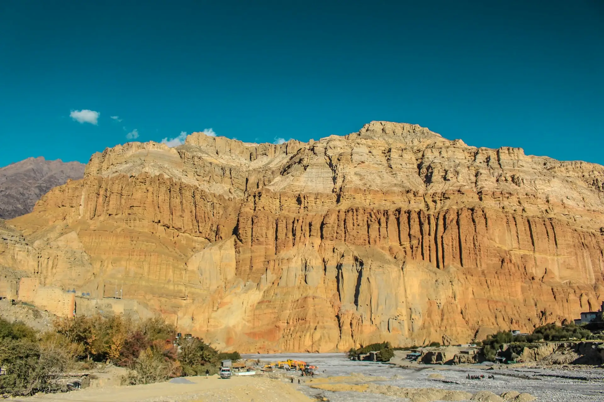
Upper Mustang sits in a geographical sweet spot that, frankly, feels like cheating. Tucked behind the Annapurna and Dhaulagiri massifs in the far north of Nepal, the region lies in a classic rain shadow zone. When the monsoon hits, those two colossal mountain ranges act as a wall, wringing the moisture out of the clouds before they ever reach Mustang.
The result: while the rest of Nepal averages 1,500 to 3,000 mm of rain between June and September, Lo Manthang and the villages surrounding it receive barely 200 mm annually. The sun keeps shining. The trails stay dry. The views remain wide open.
For French travellers used to planning around weather windows, this is a revelation. You do not need to wait for October. You do not need to fight crowds on the Everest Base Camp trail. You need a permit, decent boots, and a flight to a very small airstrip in the Himalayas.
What Makes the Monsoon Season Ideal Here
Let us be specific about what you gain when you trek Upper Mustang during monsoon (June to September):
- No mud, no leeches, no rain gear anxiety. The desert plateau stays bone dry while the rest of Nepal turns into a rainforest obstacle course.
- Fewer trekkers on the trail. The crowds that descend on the Annapurna region in spring and autumn do not come here. You will meet locals, not queues.
- Green contrast in the valley floors. Irrigation channels bring water to the lower Kali Gandaki valley, meaning you get the surreal combination of desert cliffs above and barley fields below. The photographic opportunities are genuinely spectacular.
- Wildflowers across the plateau. The brief moisture that does reach the upper plateau in early monsoon triggers wild poppies and alpine flowers. It lasts a few weeks, and most trekkers miss it entirely.
- Cooler temperatures. At 3,840 metres in Lo Manthang, summers are comfortable rather than scorching. Think Paris in early May, but with better views and no croissants.
The Route: What You Will See
The classic Upper Mustang Trek runs roughly 10 to 14 days depending on pace, acclimatisation, and how long you want to linger in Lo Manthang. Here is the broad shape of it:
Jomsom to Lo Manthang (approximately 5-6 days northbound)
The trail follows the ancient Kali Gandaki trade route, one of the deepest gorges on earth, before climbing out onto a wind-sculpted plateau of red and ochre cliffs. Villages like Kagbeni, Chele, Syangboche, Ghami, and Tsarang each have their own gompas (Buddhist monasteries), cave systems, and crucially their own way of making local raksi (grain spirit). Consider pacing yourself.
Lo Manthang: The Walled Kingdom
Lo Manthang is the former capital of the Kingdom of Lo, a quasi-independent Tibetan kingdom that maintained its own monarch, the Raja of Mustang, until 2008. The walled city sits at 3,840 metres and contains roughly 150 households, four ancient monasteries, and a palace that dates to the 15th century. Restoration work supported by the American Himalayan Foundation has preserved murals inside Thubchen and Jampa Lhakhang that art historians describe as among the finest examples of Tibetan Buddhist art outside Tibet.
The Raja’s family still lives in Lo Manthang. His daughter, Princess Kesang, has been active in tourism and cultural preservation. This is not a theme park. It is a living, functioning community that happens to look like a medieval city transported from central Asia.
The return via Nyphu Monastery and Chosar Caves
A strong alternative route loops back through Nyphu, a cliff-face monastery accessible by a short climb, and the Chosar Caves near Lo Manthang: a vast network of sky caves carved into the cliffs, some of which date back over 2,000 years. Early excavations found ancient manuscripts and human remains inside. No one is entirely sure who carved them or why.
Fun Facts: Life in Upper Mustang
Upper Mustang rewards curious travellers. A few things worth knowing before you arrive:
- The region was closed to outsiders until 1992. For most of the 20th century, it remained one of the last restricted areas in Nepal. The permit system is still in place today (currently USD 500 for a 10-day permit, required alongside a standard Annapurna Conservation Area Permit).
- The local dialect is closer to Tibetan than Nepali. Mustangi people, the Loba, maintain a distinct cultural and linguistic identity. Many elders speak no Nepali at all.
- Polyandry was historically common. Fraternal polyandry (one woman marrying multiple brothers) was practised to keep land holdings intact across generations. It is rare now, but older residents will tell you about it quite matter-of-factly.
- The apple orchards of Marpha are famous across Nepal. The village of Marpha, just south of Jomsom, produces apples and apple brandy in quantities that locals are very proud of. The brandy is not subtle.
- Horses are still the primary transport for many villages. Road construction has reached Lo Manthang, but supplies in remote areas still move on horseback. Watching a Mustang horseman navigate a cliff trail with no visible concern is quietly impressive.
For French Travellers: Practical Considerations
Nepal sees strong numbers of French trekkers each year, mostly concentrated around Annapurna and Everest in spring and autumn. Upper Mustang during monsoon is genuinely underdiscovered by the French market, which is either a cultural oversight or a well-guarded secret among those who have been.
Permits
Upper Mustang requires a Restricted Area Permit (RAP) at USD 500 for 10 days, plus USD 50 per additional day. This must be arranged through a registered Nepali trekking agency. Glacier Safari Treks handles this entirely.
Getting there
Fly Kathmandu to Jomsom (30 minutes, spectacular). Flights are subject to weather — book flexibility into your schedule. Driving from Pokhara via the recently built road is also an option for those who prefer overland travel and have a strong stomach for mountain roads.
Food and accommodation
Teahouses operate throughout the route. Expect dal bhat, Tibetan bread, and the occasional momos. Lodges in Lo Manthang have improved considerably in recent years. Nothing will remind you of a French hotel, but the hospitality is genuine and the views from the dining room compensate generously.
Fitness level
This is a moderate to challenging trek. The altitude is the primary factor. Prior high-altitude experience is helpful but not essential if you acclimatise properly. The trail itself is well-established.
Why Glacier Safari Treks for Trek Upper Mustang During Monsoon
Glacier Safari Treks has been organising Himalayan expeditions for years with a team based in Kathmandu that knows the Mustang region in detail. We handle permits, guide logistics, bookings, and the Jomsom flight coordination.
Want to trek upper mustang during monsoon season? Ask our team directly at Glacier Safari Treks. We are happy to help; plan your Upper Mustang itinerary, sort your permits, and answer questions about everything.
FAQs on Trekking Upper Mustang in Monsoon Season
1. Is it really dry in Upper Mustang during the monsoon?
Yes. The rain shadow effect created by the Annapurna and Dhaulagiri ranges blocks the vast majority of monsoon rainfall. Annual precipitation in Lo Manthang is around 200 mm. For comparison, London receives roughly 600 mm per year, and nobody describes London as a desert.
2. Do I need a special permit for Upper Mustang?
Yes. Upper Mustang is a Restricted Area, which means you need a Restricted Area Permit (USD 500 for 10 days) in addition to the Annapurna Conservation Area Permit. The RAP must be obtained through a registered Nepali trekking agency. You cannot enter the region independently.
3. What is the best month to trek Upper Mustang during monsoon?
June, July, and August are all excellent. June catches the tail end of wildflower season. July and August are peak monsoon elsewhere in Nepal but stable and clear in Mustang. September transitions into autumn, and the trail becomes slightly busier as other trekking routes open up again.
4. How difficult is the Upper Mustang Trek?
Moderate to challenging, with altitude being the main consideration. The highest point on the standard route is around 4,600 metres. Fitness matters, but proper acclimatisation matters more. If you have trekked at altitude before (say, Mont Blanc or a Pyrenean pass), this is a step up in altitude but not necessarily in technical difficulty.
5. Can I trek Upper Mustang without a guide?
No. The Restricted Area Permit requires that you trek with a registered guide from a licensed agency. Beyond the legal requirement, it is also genuinely useful: the trails are not always marked, villages speak limited English, and a good guide significantly improves the experience. Glacier Safari Treks provides experienced, English and French-speaking guides.